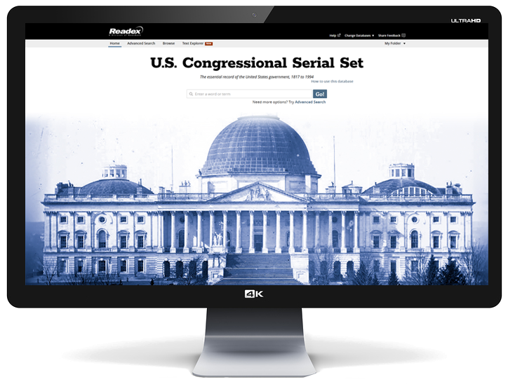
U.S. Congressional Serial Set
1817-1994
- A foundational resource for studying American history, society and politics
- The definitive digital edition of more than 370,000 original government publications
- Superior search results, unique browse capabilities and comprehensive bibliographic records


"The Serial Set is an incredibly rich full text resource of reports, documents and journals of the House and Senate. It provides an amazing view of the history and culture of the United States from 1817 to 1994. The database is fully searchable by subject, personal names, places and acts. You can download and print text and images in full color. The resource also includes an impressive collection of maps of territories and states covering a wide range of subjects that are researched by the Congress. There is even a collection of pre-1800 maps including subjects you might not expect like Attila’s empire and Ptolemy’s view of the world. Check it out!"
— William Mitchell College of Law, Warren E. Burger Library, Blog (Feb. 2012)
“Patrons of libraries that buy this Readex Set will enjoy using this excellent product.”
— L. M. Stuart, Johns Hopkins University, in Choice (July 2010)
"The online U.S. Congressional Serial Set by Readex is a thing of beauty, with tremendous added value in the extensive indexing."
—Katherine Holvoet, Head, Government Documents, University of Utah, in Against the Grain (September 2006)
“It's 3 a.m., and you're writing a paper. You need to know what George Washington said to the House of Representatives about the situation in Europe in 1793…. So who do you turn to?
“Students can find answers to their queries through the U. S. Congressional Serial Set database, an online compendium of documents published by Congress from 1817 through today….
“Congress later realized that all documents generated before 1833 were difficult to access. So it retroactively published a set called the American State Papers, which is a 38-volume collection of documents dated between 1789 and 1838.
“Topics like slavery in pre-Civil War America, women's rights and American western expansion are covered in a wealth of documents in the papers…. “In sorting the documents, Readex broke them down into a variety of subcategories by subject matter. Whether a person needs to read documents about the Treaty of Ghent, the South Sandwich Islands or the Republic of Texas, all are readily available and easy to find.
“The ability to view scanned, searchable copies of documents that are more than 200 years old gives members of the University community a unique opportunity. Students can study the issues and conflicts that shaped the United States as a nation in the very words of those that shaped it.”
—Joseph Shure, The Daily Targum, Rutgers University
"The Readex interface is straightforward and user-friendly with many options for efficiently searching, navigating and retrieving the extensive and complex collection of government information in the Serial Set. Most important, the primary database use options are prominently displayed at the top of the screen to matter where one is in the database. This effectively gives even the novice user a sense of control and mastery.
"Readex created a complete bibliographic record for each document in the Serial Set Digital Edition that greatly enhances the probability of searching success. It is this superior level of indexing that makes finding information so good.
"The Readex database is not the only source for a digitized version of the Serial Set.... The Readex database though is one of the most complete, and its browse and search functionality seem superior to any that this reviewer has tried.
"We should all be so fortunate as to be able to add this impressive database to our library collections. Our students and faculty will thank us if we do."
—Barbara Norelli, Social Sciences & Instructional Services Librarian, Skidmore College, in Microform & Imaging Review (Winter 2005)
“Readex delivers scholarship and browsability.”
—Ann E. Miller, Federal Documents Librarian, Duke University, in Documents to the People (Summer 2005)
“The Readex U.S. Congressional Serial Set, Digital Edition, when complete, will cover a longer period of the Serial Set publication than any other digital resource available ….Although a digital product, the database retains the historical taste of the print collection. Everything on the screen is thoughtfully designed and organized to allow the convenient use of the database without a librarian’s help. The interface is intuitive and easy to learn and follow...Readex designed all kinds of browsing and searching options.”
—Jian Anna Xiong, Assistant Professor/Government Information Librarian, Southern Illinois University at Carbondale, in The Charleston Advisor (April 2004)
“The U.S. Congressional Serial Set is the single most valuable resource on U.S. history, economy, international relations, law, politics and society…
“The Serial Set digital edition is part of Readex's Archive of Americana, which aims to provide a comprehensive collection of primary source documents in American history, literature and culture. The interface will be familiar to users of Readex products such as Early American Imprints or Early American Newspapers. It utilizes a clean, uncluttered style where users can search or browse publications from the home page or top of each screen.
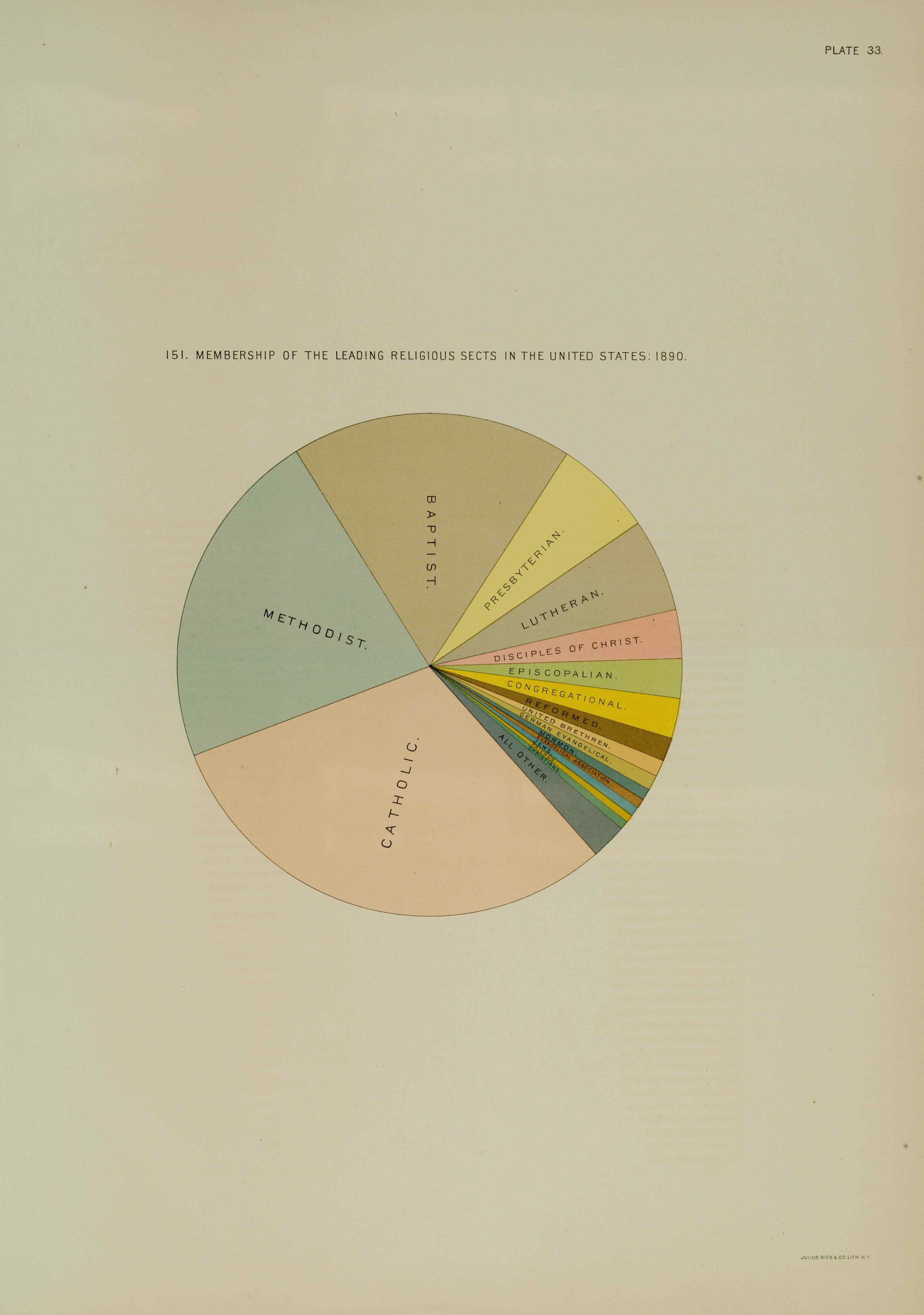
“Browsing is facilitated by using pre-determined subject categories organized hierarchically. A default basic search screen allows a keyword search within a citation or selected fields, while an advanced search allows users to link searches with “And”, “Or” or “Not”, to perform field and full-text searches and set limits by date. Given the large proportion of statistical tables, maps and illustrations in the collection, the ability to limit searches to documents containing these features is extremely useful….
“With a collection this large and spanning such a long period, subject searching using controlled vocabulary and authority control become critical, as changes in terms and vocabulary render free-text searching problematic. The large number of congressional, agency and organizational corporate authors in these volumes (the bane of many a searcher) make the care taken with authority control a great benefit. The availability of free-text searching (excluding most text on maps, illustrations and statistical tables) deftly complements the other search options, and supports research needs of literary and linguistic scholars….
“Color illustrations and maps are of extremely high quality. In contrast to many electronic products, Readex's Serial Set captures much of the feel of the original print documents.”
—Hui Hua Chua, U.S. Documents Librarian, Michigan State University, in Reference Reviews (Volume 19, Number 4 2005)
“Readex’s ambitious digitalization of the U.S. Congressional Serial Set has provided unprecedented and convenient access to a mountain of valuable source materials. The abundant and wide variety of information contained in the Congressional Serial Set serves many different disciplines, including Asian Studies and Asian American Studies. The contribution that Chinese laborers made to building the transcontinental railroad is one of the many interesting topics documented in the Set.”
— Suping Lu, Professor and Liaison Librarian, University of Nebraska-Lincoln
“When I set out to write a biography of Cornelius Vanderbilt, a man known by the informal title of “Commodore,” I faced one mystery after another. Even though he was one of the richest and most powerful businessmen in American history, he conducted most of his operations in secret. He left no diary, no collection of papers, and carried out many transactions orally, without committing them to paper....I was ready to indict and convict Vanderbilt of war profiteering, if that’s where the evidence led me. Instead, it convinced me that the Commodore deserved his gold medal. Vanderbilt has often been treated with cynicism by historians, who are ready to believe the worst of a staggeringly rich, secretive, and combative man. Certainly I did not set out to rehabilitate his reputation. But I couldn’t ignore the evidence—evidence provided in breathtaking abundance by Congress in its Serial Set, now more accessible than ever thanks to digitization.”
— T.J. Stiles, author of The First Tycoon: The Epic Life of Cornelius Vanderbilt, 2009 National Book Award Winner
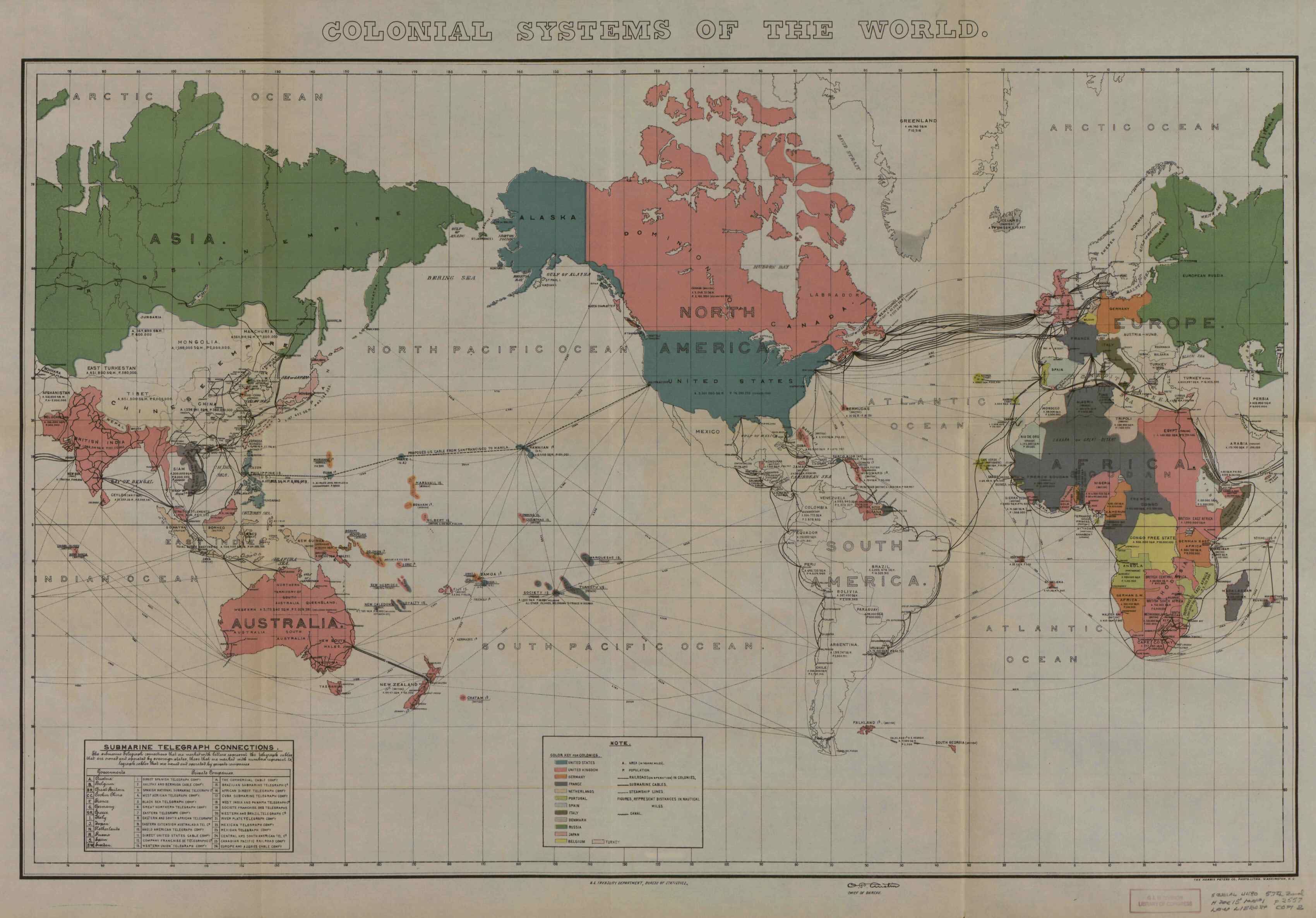
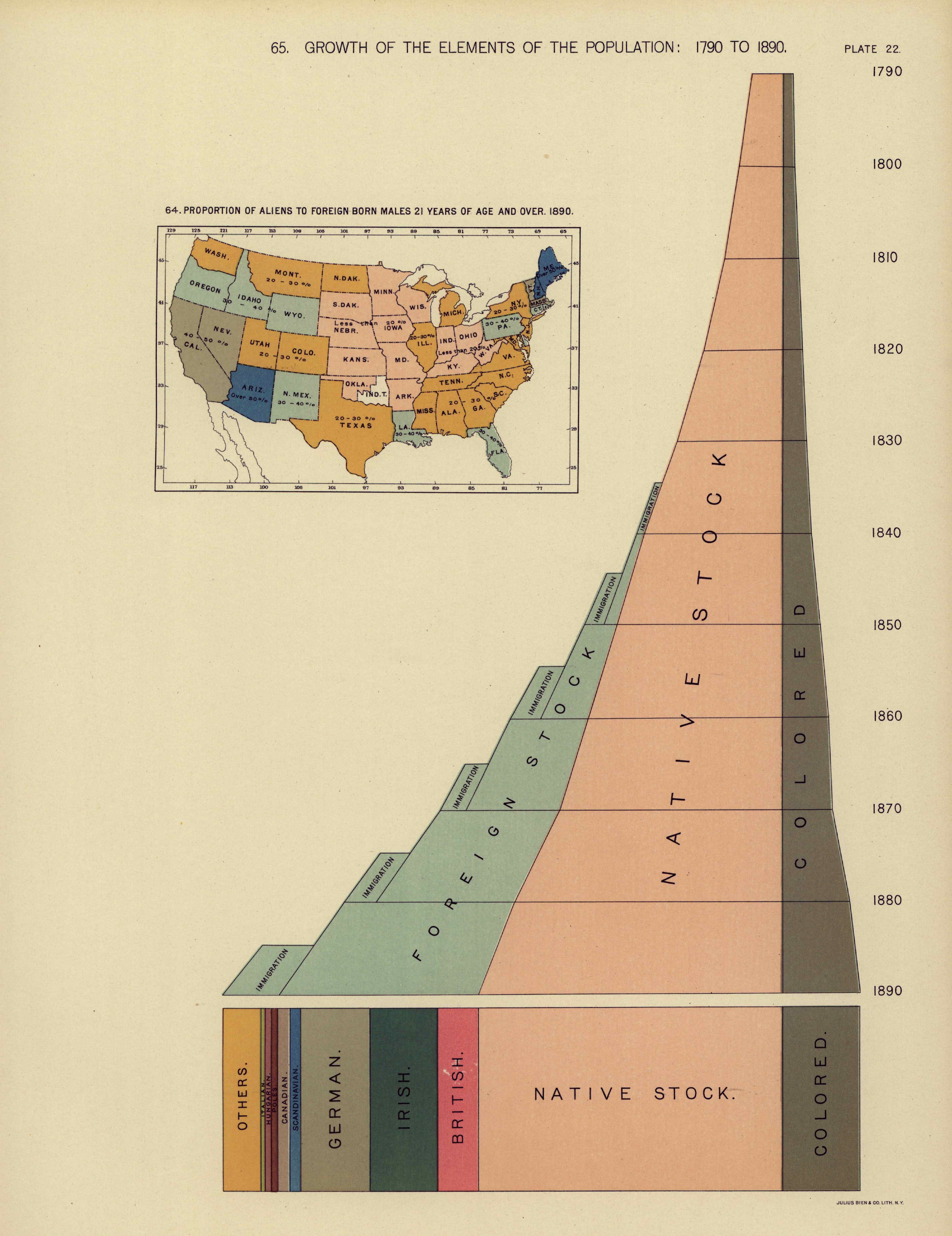
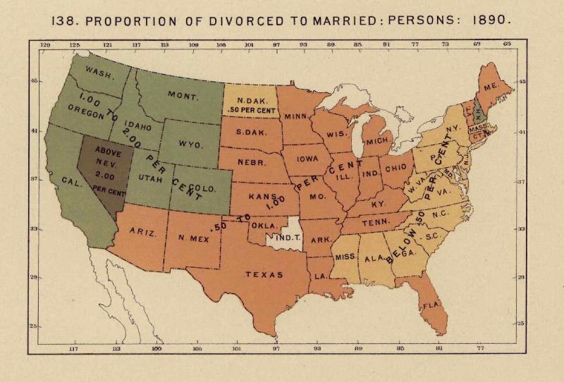
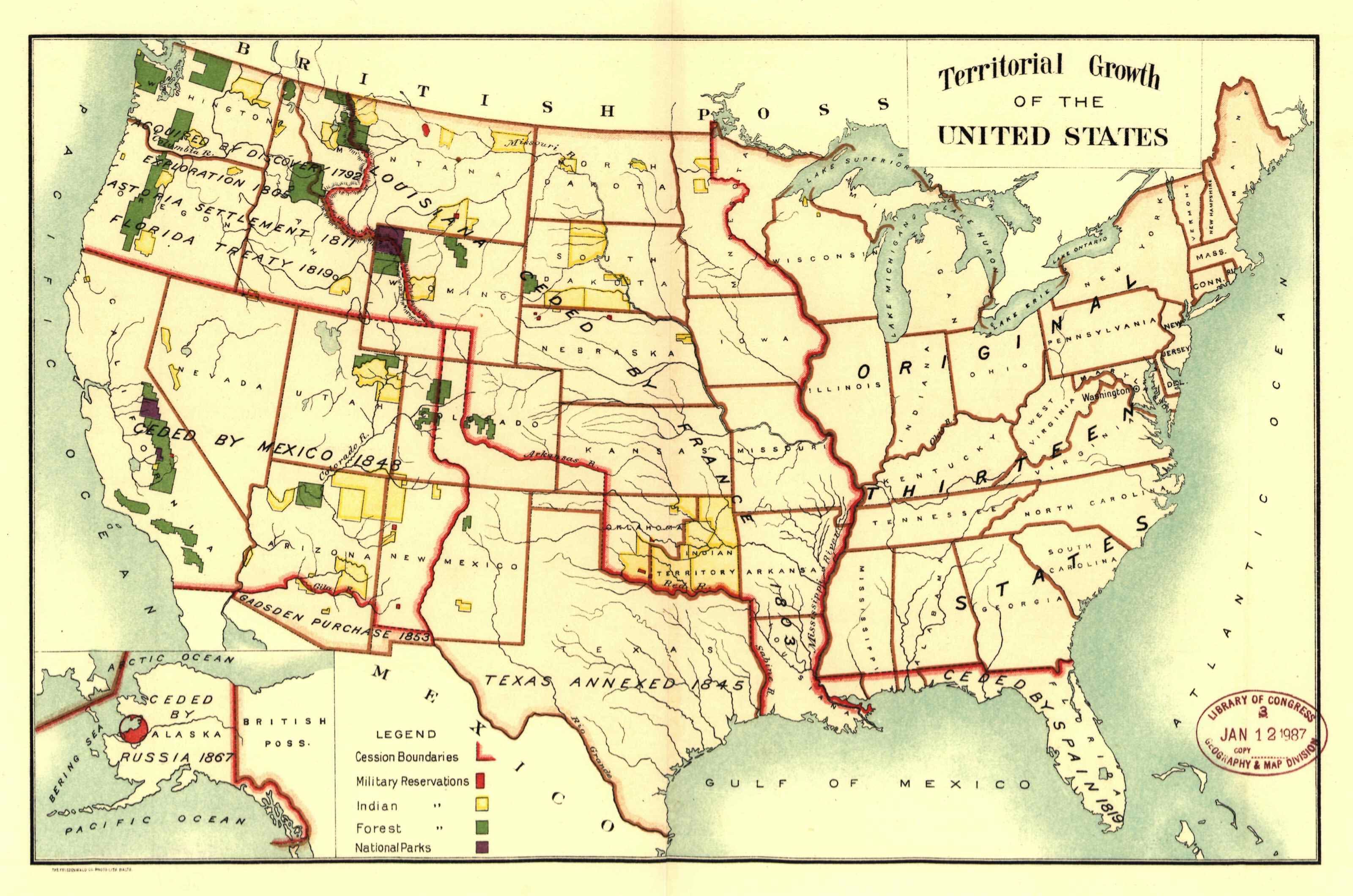
“The U.S. Congressional Serial Set illustrates the important role of rivers through its collection of more than 50,000 maps, many in full color. In addition to its vast number of U.S. maps, the Serial Set includes maps from locales as widely scattered as Asia, South America and the Yukon Territory....Beyond their contributions to navigation and exploration, maps serve as graphic reminders of a region's history, people and politics. The maps of the U.S. Congressional Serial Set illustrate the physical features of land and waterways around the world and—through accompanying journals and sketches—offer insight into the people, culture and times that produced them.”
— Donna Koepp, former head of government documents/microforms and head of reference and instruction for the Harvard College Library's Social Sciences Program
“In December 2009 and at the end of a thirteen-year journey through three administrations and an array of proceedings against four Secretaries of the Interior, a Class Action Settlement Agreement was reached in Cobell v. Salazar before the United States District Court for the District of Columbia. This accord recommends a two-part resolution to claims of alleged federal mismanagement of American Indian tribal funds and other assets, resulting from the government’s failure to meet its fiduciary responsibilities as specified by the General Allotment Act of 1887....Serial Set materials create a foundation for an understanding of the Cobell proceedings. Readex’s extension of the Serial Set database through the 103rd Congress will bring these effective digital search capabilities up to the very threshold of these judicial events, thereby increasing the scope of any investigation.”
— Charles D. Bernholz, Professor and Government Documents Librarian, University of Nebraska-Lincoln
“Latin American Newspapers, 1805-1922 and the U.S. Congressional Serial Set, 1817-1994 are two databases of great importance for Latin American studies. Together they provide more than 30 newspapers and 400,000 government documents that provide Latin American researchers with access to critical historical information without requiring travel to the United States or neighboring countries. These high-quality Readex collections offer new opportunities to explore, understand and reveal our own history; both are of huge value to historical researchers in many different fields of the humanities and social sciences.”
— Prof. Kátia Couto, Department of History, Universidade Federal do Amazonas-UFAM
“The Readex digital U.S. Congressional Serial Set is a great boon to scholars of 19th-century America, making instantly accessible a wealth of information and documentation previously very difficult to locate and access.”
— Eric Foner, DeWitt Clinton Professor of History, Columbia University
“The ‘U.S. Congressional Serial Set’ provides essential primary sources in humanities, social sciences and even some science areas. With information coming from every level and agency of government, the ‘Serial Set’ is a virtual encyclopedia of America, replete with information on everything from alcoholism to Zanesville, Ohio. At my institution, the ‘Set’ supports 56 courses across eight departments and makes a strong contribution to the liberal arts curriculum.
“The Readex Serial Set supports faculty and student research and gives them tools, unavailable until now, to mine this rich vein of knowledge. A well-designed database that goes far beyond the essentials, the Readex edition opens up the resources in ways that make them readily accessible to undergraduates. Very few databases actually invite users to explore their contents the way this one does. It puts a sense of discovery back into the learning process and allows users to exercise considerable control in their searching.
“The interface is laid out logically, easily and with all important functions always available, whether in search or display mode, on the top half of the visible screen. There is never any doubt as to what the user’s options are at any point in the process—whether that is to view the document, search within the results, ask for help or download a document. The only directly similar databases in structure are the digital Early American Imprints and Early American Newspapers, also published by Readex.
“The best source for undergraduate and faculty research, the Readex Serial Set stands as the preeminent edition of the ‘Serial Set’ in terms of enhanced and value-added access. I strongly recommend the Readex Serial Set as an investment in permanent and enhanced access to the major historical record of the United States.”
— Gerald L. Gill, Professor, Head of Reference and Government Documents, James Madison University
"The U.S. Congressional Serial Set will make unearthing debates in Congress over slavery and abolition, among many other topics, a far simpler and efficient process. I recommend the Archive of Americana to any scholar, student or layperson as the most speedy and rewarding way of conducting historical research today.”
— Manisha Sinha, Associate Professor of Afro-American Studies, University of Massachusetts, Amherst
“The Readex digital U.S. Congressional Serial Set provides our faculty, students, and other patrons almost unlimited access to the primary documentation of United States history. Its usefulness was immediate: two days after purchase a history department professor assigned class work with this collection.
“In my own research on American Indians, I have found the enhanced indexing to be enormously helpful, the color maps especially valuable for study, and the search capabilities highly effective. The Personal Names and the Groups of People subject indexes let me quickly pinpoint relevant documents. The Legal System index option affords prompt access to treaty and claims materials. The Standing-Committee Author index supports the complete investigation of the results of specific Committees relevant to my inquiries.
“The University Libraries are very pleased with the Readex digital Serial Set and expect to have high patron usage.”
— Charles D. Bernholz, Government Documents Librarian, University of Nebraska-Lincoln
How do U.S. Congressional Serial Set users access Serial Set Maps?
Access is available in four ways: 1) from all search pages of the U.S. Congressional Set; 2) from every Serial Set publication containing an indexed map; 3) from InfoWeb, the web page that provides access to all available NewsBank and Readex collections; and 4) by a direct link available to customers.
How do users of the Serial Set know which maps have been indexed?
Users can learn which maps have been indexed through the "covered years" text on the home page under Search Hints. Expanded information, including corresponding Congresses and Serial Set volumes can be found under Background/Product Status within the Help section.
What are a few of the special features of Serial Set Maps?
Features include: search and browse capabilities designed for maps; ability to search specifically by dates related to the maps rather than the dates assigned to Serial Set publications; indexing of subject and geographic locations specific to the maps; citation records providing map title, Serial Set publication, map date, issuing body, cartographer or author, coordinates, scale, content notes and geographic location and subject indexing; linking of related maps within a publication or multi-page maps to enable easy navigation; a process based on physical review of original publications to ensure that a high-resolution image and citation record is created for every map; citation records that can be emailed with a click; provision of suggested related search terms based on the acclaimed Readex Congressional Thesaurus.
What is the difference between a Serial Set citation search limited to maps and a Serial Set Maps search?
A Serial Set citation search limited to maps will return all publications with metadata meeting the search criteria that also include one or more maps. Such a search is made against the metadata applied to Serial Set publications, not the metadata applied to the Serial Set maps.
The same search in Serial Set Maps will return all maps with metadata meeting the search criteria. Map citation records do not contain all indexing terms that parent publications contain, nor do citation records of parent publications contain all indexing terms applied to maps within.
How is Readex Serial Set map indexing different than Readex Serial Set publication indexing?
A dedicated team of experienced map indexers is responsible for creating the Serial Set map citations. Map citations include metadata not relevant to Serial Set publications, such as scale and coordinates. Dates applied to the maps are also independent from the dates assigned to the publications. The terms applied are specific to the cartographer, subject and locations represented on the map, not to the Serial Set publication in which a map was published.
Which authority sources are used to index Serial Set maps?
Sources include the Getty Thesaurus of Geographic Names, the U.S. Geological Survey's Geographic Names Information System (GNIS), Library of Congress (LC) Authorities, National Agriculture Library (NAL) Thesaurus and specialized place name directories on the Internet.
In addition, a proprietary Vocabulary Authority, actively controlled, maintained and supplemented by Readex Serial Set editors, ensures consistent and extensive application of terms to like subjects, geographies and names in both the Serial Set and Serial Set Maps.
What expertise does the Readex map indexing team bring to this effort?
Donna Koepp is the Editor of the "CIS US Serial Set Index: Part XIV, Index and Carto-Bibliography of Maps, 1789-1969." Koepp holds an M.A. in Librarianship and has 32 years of experience as a Government Documents and Map Librarian.
Vicky Bedi has an M.S. in Library Science. Bedi has been a cataloger of maps in Dartmouth University Library Special Collections and Maps Collection. She has more than 11 years of related experience.
The map indexing team published "Rivers Run Through It: The U.S. Congressional Serial Set and Its Maps" in the April 2009 issue of the Readex Report.
How many maps appear in the Readex U.S. Congressional Serial Set, 1817-1980?
The total number of maps is 74,495. Each is accompanied by a citation record.
How does Readex's count of Serial Set maps account for individual maps that contain additional inset maps?
Inset maps are indexed as part of the larger map. Inset maps are not separately indexed, nor are they counted separately. Each map citation record counts as one map. In a small percentage of cases, a multi-page map is counted as one map, because it is indexed as a single map, although printed on more than one page.
How many Serial Set maps were originally printed in color?
We estimate that more than 13,000 of the 74,495 Serial Set maps were printed in color.
What are Readex's sources for the maps in its Serial Set?
Black and white maps are scanned from Serial Set volumes borrowed from the libraries of Dartmouth College, University of Vermont and the U.S. Senate. Color maps are scanned from those in the collection of the Geography and Map Division of the Library of Congress.
Why is the Library of Congress a superior source for these maps?
The Library of Congress has expertly removed the Serial Set maps from a rarely used Prestige Edition of the Serial Set and carefully stored them flat in folders. By using these superior maps, crease lines are less pronounced and other issues related to condition are minimal. At the Library of Congress's Geography and Map Division, these well-preserved maps can be digitized on a high quality jumbo scanner, reducing the number that must be stitched together from multiple images.
Are the digital images of the Serial Set maps prepared differently than other pages of the Serial Set publications?
Yes, digital images for maps are handled in different ways, depending on their size and color. Every map is digitized at 400 dpi, 24bit color. Maps contained within the standard page size of Serial Set volumes are scanned on a Kirtas APT BookScan. In addition, a high-resolution TIFF image is created in PhotoShop. Black-and-white maps larger than the standard page size are filmed with a Phase One P45 for Hasselblad and then created as TIFF images in PhotoShop. If more than one image is required to capture the whole map, the map stitching is also done in PhotoShop. Most color maps are scanned at the Library of Congress using their jumbo scanners.
In which formats are the Serial Set maps available for downloading and why?
Map images are available in PDF and TIFF formats. The PDF format is provided for consistency with the format provided for the pages of Serial Set publications. TIFF images are available to provide users with the capability to print over-sized maps to scale. TIFF images can also be used for geo-referencing.
Can users print large maps, that is, maps larger than an 8.5 x 11-inch sheet?
Yes. Users with standard printers can choose to print a selection from a larger map, or print on an 8.5 x 14-inch sheet. In addition, users can instruct their printer to "fit image to page." Those able to print on sheets larger than 8.5 x 14 may download TIFF images to a local drive and use local software to print.
What is geo-referencing? What kinds of users might want to use our TIFF images for this and why?
In simple terms, geo-referencing is placing coordinates on a map to fix its location on the face of the earth. It can be used to combine data from more than one map, and to enable comparisons of old data with current data.
Here's an example of how geo-referencing might be used with Serial Set Maps. The Serial Set's many Washington, D.C. maps present a treasure-trove of information, including instances of diseases and fatalities by block; location of schools; location of sewer and water lines; public transportation and much more. These maps are mostly presented on the same scale and projection, but no coordinates are given. By adding accurate latitude and longitude references, these maps can be compared with other maps, both historical and current, using today’s GIS technology.
When is Readex's indexing of the maps in the U.S. Congressional Serial Set, 1817-1994 expected to be complete?
Map indexing was completed in March 2013.
What perhaps surprising subjects are covered by Serial Set Maps?
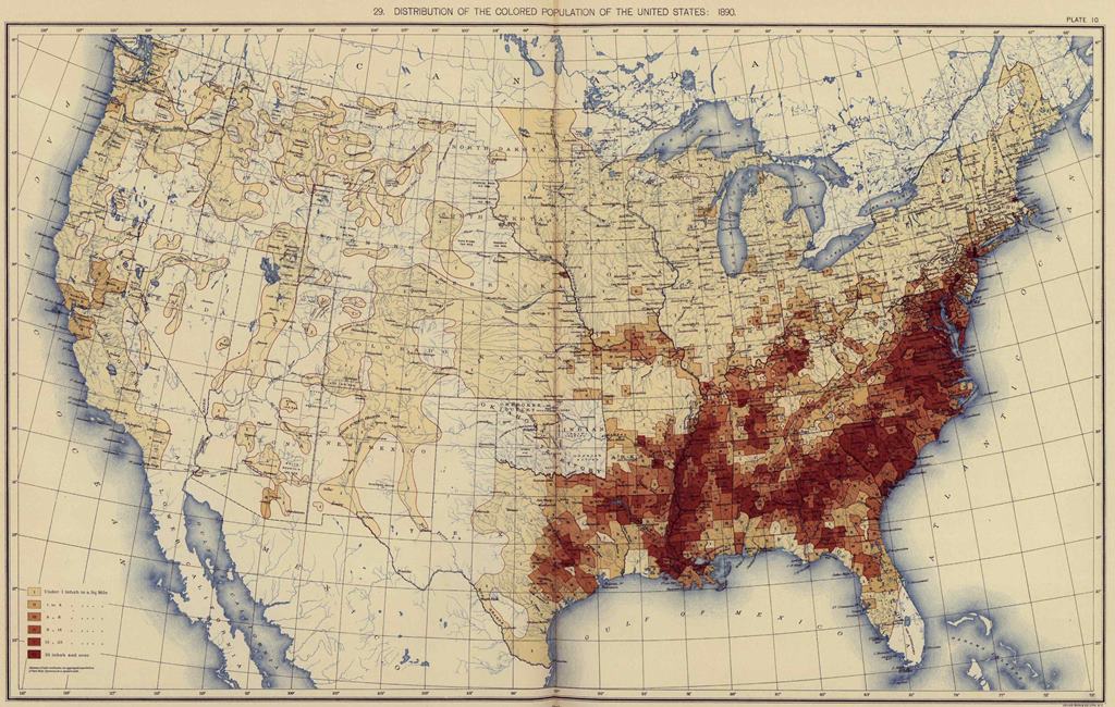
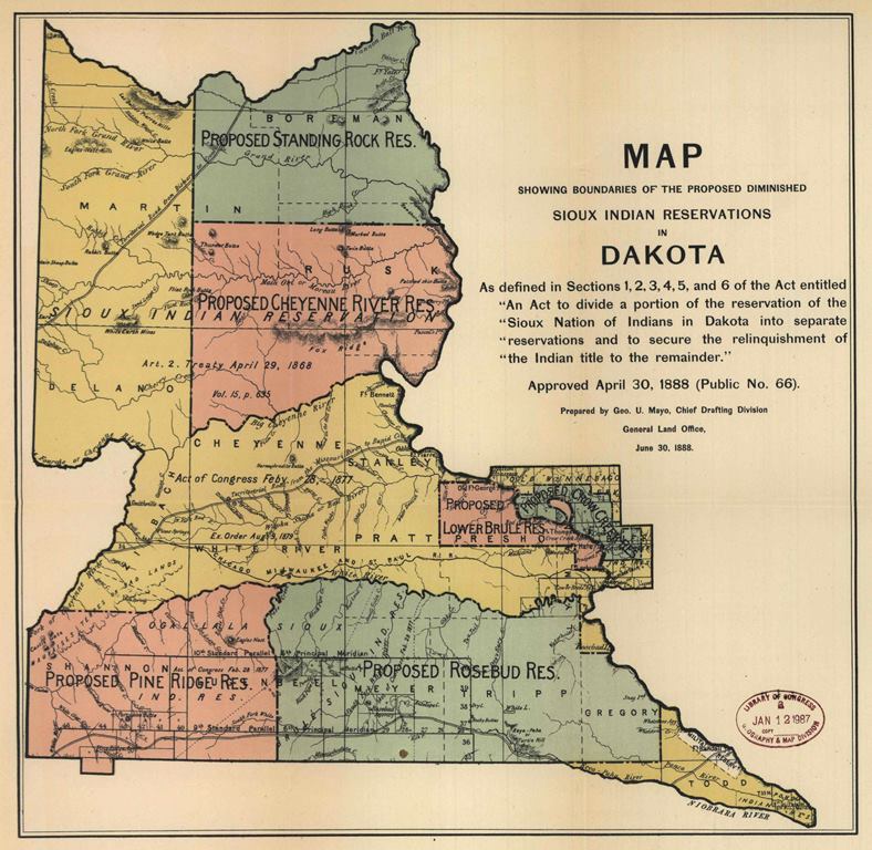
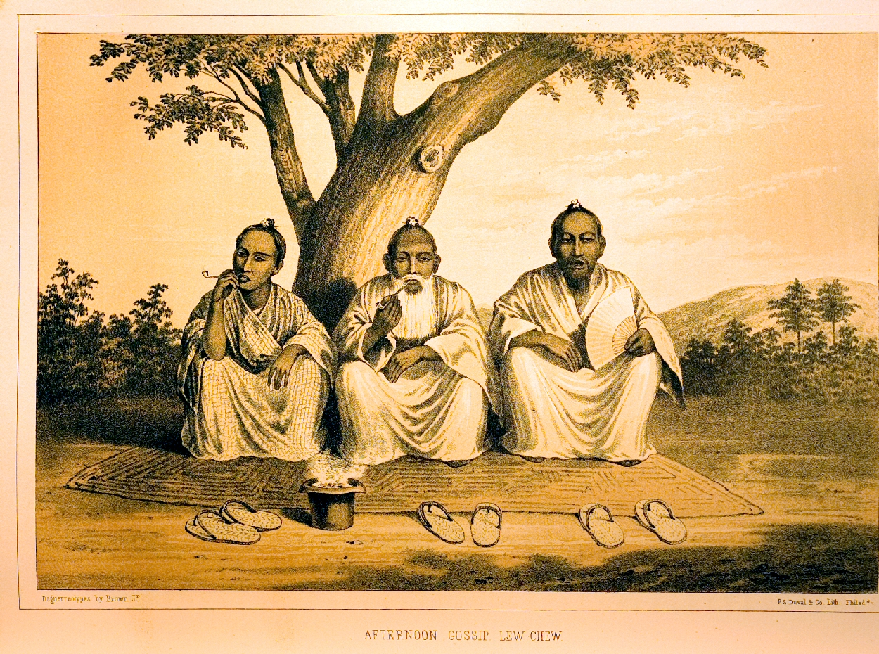
Examples include the spread of diseases, both animal and human; evolution of air routes; railroad acquisitions and mergers, including railroad routes; Indian reservations, including migration and border changes; rivers, including development of navigation, exploration, locks and dams and flood control; public land and railroad surveys; Boxer Rebellion; Commodore Perry Exploration of the Orient; Jeannette Expedition; Philippine War; irrigation development in India; weather; Civil War; census information; voting and political districting and many others.
Could you please highlight a few Serial Set maps of special note?
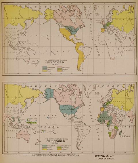
Examples include the following: Atlas of color plates of federally controlled land in the District of Columbia; Plans for pneumatic tube facilities for postal delivery; Chart showing the original milestones of the District of Columbia by L'Enfant; A pair of world maps comparing areas that had been mapped in 1860 and 1915; Map depicting the poliomyelitis epidemic of 1916; maps relating to the Yakatut Bay, Alaska, earthquake of 1899, and illustrating the resultant "shattering" of Muir Glacier; Congressional district maps, 1909 and 1910; maps accompanying the U.S. Immigration Commission report on immigration, including racial/ethnic neighborhood maps of major U.S. cities; Historical map of the distribution of banking capital in New York State in 1836; maps relating to Jews and Eastern European ethnic groups from William Z. Ripley's The Races of Europe (1899); maps accompanying The Ethnogeography of the Tewa Indians, by linguist and anthropologist John Peabody Harrington; Holy Land map from Thomas Jefferson's Bible; map of the world by Leonardo da Vinci; Waldseemuller maps of the world from the 1500s; maps depicting historical boundary changes among U.S. states and territories; historical maps of the U.S. Military Academy at West Point; map accompanying report of frozen mammoth found in Siberia; Map illustrating Peary's North Pole Expedition (1898-1902); map containing data on aliens in prisons and charitable institutions in the United States; 31 battle and other maps related to World War I, including the Marne and Meuse-Argonne; Chronological map of the influenza epidemic of 1918 in the United States; Map of the United States showing routes of the principal explorers from 1501 to 1844; Geological reconnaissance maps of Alaska; maps of the National Parks from 1918, including tourist maps; Map showing the prehistoric migrations of the Slavs in Bohemia and Moravia; Map summarizing American deaths in the Mexican Revolution, 1910-1920; and many others.
How do users who leave the Serial Set to see a map citation return to where they were?
From a Serial Set Map citation or map image, users can click on the external link under "From Serial Set Publication" in the upper right quadrant.
What do Serial Set Map citations look like?
Here are two:
Title: Chart of part of the Bahama Islands showing the tracks ascribed to Columbus on his discovery of the New World. [Coast and Geodetic Survey report, 1880. No. 83]
Date: 1492
From Serial Set Publication:
Serial Set No. 1942, Session Vol. No.2
46th Congress, 3rd Session
S.Exec.Doc. 12, Page [Not Numbered]
Map No. 58
Event Date: 1492
Map Creation Date: April, 1881
Issuing Body:
U.S. Coast and Geodetic Survey (1878-1970)
Personal Names:
Barnett, E.
Becher, A.F.
Bright, W.T.
Columbus, Christopher
De Naverrete, M.F.
De Varnhagen, F.A.
Fox, Gustavus Vasa
Irving, Washington
O'Sullivan, T.J.
Owen, R.
Subjects:
Columbus' landfall in America (1492)
Discovery and exploration
Hydrographic surveying
Islands
U.S. Department of the Navy. Bureau of Navigation. Hydrographic Office
Acklins Island
Bahamas
Clarence Town, Bahamas
Long Island (Bahamas)
Samana Cay
Turks and Caicos Islands
Contents Note:
Includes five inset maps: Crooked Island anchorages; Acklin Island, N.E. part. surveyed by Comdr. R. Owen, R.N., 1832; Long Island, lower part. From U.S. Hydrographic Office chart, corrected to 1872; Samana, or, Atwood Cay. Surveyed by Comdr. R. Owen, R.N., 1832; Clarence Harbor. Surveyed by Capt. E. Barnett, R.N., 1834.
Coordinates: W77°52'--W19°36' / N25°00'--N19°36'
Physical Description: color map
Language: English
Copyright © 2005 by NewsBank, inc. All Rights Reserved.
Record Number: 10E38DF0C834A1B8
OpenURL Article Bookmark (right click, and copy the link location):
Serial Set No. 1942, Session Vol. No.2 S.Exec.Doc. 12, Page [Not Numbered]
and
Title: No. 2. Mapa general, Islas Filipinas Observatorio de Manila. [United States Coast and Geodetic Survey. No. 2]
Date: [January 1, 1900]
From Serial Set Publication:
Serial Set No. 3885, Session Vol. No.47
56th Congress, 1st Session
S.Doc. 138 pt. Atlas, Page [Not Numbered]
Map No. 2
Parent Document Date: [January 1, 1900
Issuing Body: U.S. Coast and Geodetic Survey (1878-1970)
Subjects:
Islands
Oceans and seas
Pacific Ocean
Philippines
South China Sea
Coordinates: E114°--E129° / N22°--N04°
Physical Description: color map
Language: Spanish
Copyright © 2005 by NewsBank, inc. All Rights Reserved.
Record Number: 11499AD0C59A8E18
OpenURL Article Bookmark (right click, and copy the link location):
Serial Set No. 3885, Session Vol. No.47 S.Doc. 138 pt. Atlas, Page [Not Numbered]