Exploring the 'Boston Foster' Map Mystery: Using Current Writings to Discover the American Past
In the October 17, 2005 issue of "The New Yorker," William Finnegan writes about a man who walked into the Beinecke Library at Yale University in June of 2005 and left shortly afterwards in handcuffs. Finnegan's fascinating article, "Annals of Crime—A Theft in the Library," details the case of noted map dealer E. Forbes Smiley III, who was arrested and charged with three counts of larceny earlier that year for slicing several maps from rare books in a Beinecke reading room.
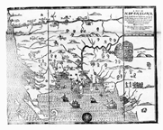
At the time of his arrest, Smiley had in his possession eight maps, four of which Yale immediately claimed were from its holdings and were valued at more than $328,000. Among the other four was the first map printed in North America. Drawn by John Foster in 1677 and known as the "Boston Foster," this famous map had originally been folded into a copy of William Hubbard's book "A Narrative of the Troubles with the Indians." Without the map, the book is worth about $35,000; with the map, it is worth more than $250,000, according to William Reese, an expert on early Americana. Smiley's copy, it later turned out, was not an original but a facsimile, further adding to the mystery.
Eager to know more, I wondered whether the Hubbard book and possibly even the map would have been included in Readex digital edition of Early American Imprints, Series I: Evans, 1639-1800. Based on Charles Evans' "American Bibliography of Early American Imprints (1639-1800)," Early American Imprints, Series I includes virtually every book, pamphlet and broadside printed in America over this 160-year period. With Web-based access to this digital edition, I thought I would find out.
Knowing the author's name (William Hubbard), I selected the "Browse by Author" tab, chose the letter "H" and scrolled down to Hubbard, William, 1621 or 2 –1704. Clicking on the author's name linked me directly to a chronological results list of five citations to imprints by Hubbard. To my surprise, citation two was the desired item: "A narrative of the troubles with the Indians in New-England, from the first planting thereof in the year 1607. to this present year 1677. But chiefly of the late troubles in the two last years, 1675. and 1676. To which is added a discourse about the warre with the Pequods in the year 1637. And following the title in the brief bibliographic citation were these exciting words in the book's pagination details: "folded leaf 1 map."
Selecting "Full Citation" brought up the complete bibliographic citation. Here, under the "Printers, Publishers, Booksellers" field, was the revelation that "Foster, John, 1648-1681, printer" was indeed the printer of the book. In addition, the "Other Index Points" field identified the same Foster as an engraver. Interestingly, when I selected the link for "Foster, John, 1648-1681," I discovered that there are 79 imprints in Early American Imprints, Series I printed by John Foster. However, there is only one map.
Returning to the full citation of "A narrative of the troubles with Indians," I was drawn to the "Notes" field. Apparently, two editions of William Hubbard's book once appeared in print and were referred to as the "White Hills" and "Wine Hills" variants by bibliographers, map collectors and historians. The White Hills are located in New Hampshire. We know from examining the full citation that our book was published in Boston, but determining which variant it was required an examination of the map itself.
Scrolling through the table of contents in the left hand margin, I decided first to view the page identified as "Misc. Front Matter (Image Page 1 of 247)" and then the "Title Page (Image Page 2 of 247)". These two displays confirmed that this is the correct book.
Display #1

Display #2

Next I scrolled down and clicked on "Image Page 144 of 247," which in the table of contents is identified as Page [Not Numbered]—Illustration and follows Page 132 of 247.
This link displayed a black-and-white woodcut map of New England, which Finnegan described in his "New Yorker" article as "a homely, Puritan, frontier map." And there on the right-hand side, just underneath the map's legend, were the words "The White Hills" confirming this map as the Boston edition, and therefore the first map published in the English colonies of North America—possibly the first map published in the Western Hemisphere.
The "Boston Foster" Map

We also know from Finnegan's article that a London edition of the book was also published a few months after the "Boston Foster." This far less valuable edition carried the name of "The Wine Hills" of New Hampshire.
There is a large market for rare and antique maps around the world. But because very few copies of this particular book and map are known to exist and because even fewer are in private hands, many believe E. Forbes Smiley III turned to other sources. Universities, large public libraries and historical societies that until just a few years ago lacked the security to protect their priceless treasures appear to have been visited and taken advantage of by Smiley.
Fortunately, digitization of the "Boston Foster" and other important early publications in Early American Imprints, Series I makes such scarce material more accessible to students and scholars.


