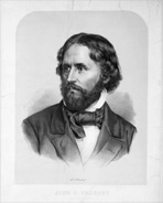
Although John C. Frémont faded into relative obscurity in the 20th century, he was without question one of the best known public figures of his time. He may also be one of the few individuals not a president, cabinet member or longtime member of Congress whose career is so fully documented in the U.S. Congressional Serial Set. More importantly, he may be the only 19th-century figure whose public career was launched and sustained by Serial Set publications.
Frémont was an explorer and cartographer, an author, a Civil War general and departmental commander, a wealthy entrepreneur and railroad speculator, not to mention a senator, presidential candidate and territorial governor. However, today his name is perhaps best known to Americans for the 2.1 million lights that are part of the sound and light show on Fremont Street in downtown Las Vegas, the home of the much-broadcast World Series of Poker.
Frémont's military career began when a family friend obtained for him a commission from President Van Buren as a Second Lieutenant in the newly organized Corps of Topographical Engineers with an assignment to accompany the French émigré astronomer and cartographer Joseph N. Nicollet on an expedition to map the upper Mississippi drainage.
He immediately began to appear in the Serial Set (H.Doc. 2, 25-3, [et al.]). I am convinced that even Frémont's most recent biographers have not seen these tables recording officers' names and the amounts of money for which they were responsible. It is only because they are now full-text searchable through the digital U.S. Congressional Serial Set, 1817-1980 that these minor sources are accessible, and it is only a very small hint of what scholars of the near future will be able to discover in the obscure corners of this goldmine.
Through Nicollet, Frémont met Thomas Hart Benton, the powerful and influential Democratic senator from Missouri who eventually became Frémont's patron and father-in-law. Benton arranged to have Frémont lead a second northern expedition to fill in details needed to complete the map of the now infirm Nicollet. It is interesting to note that the printed reports of both expeditions misspelled the leaders' names. Poor Joseph Nicollet is dead by the time the first report (S. Doc. 237, 26-3) is issued and he appears on the cover as I.N. Nicollet. Frémont appears on the cover of the second report (H. Doc. 38, 27-3) as Lt. Tremont.
The following year, Benton obtained for the young and inexperienced Frémont the assignment to head an expedition to map the Oregon Trail after Nicollet, its intended leader, died. The 1842 expedition is the beginning of everything for Frémont.
Although Frémont would later be called the Great Pathfinder, in fact he rarely found paths. The 1842 expedition followed wagon trains the whole way; 1842 was the year when the first wagons reached Oregon. His report always refers to his route as the "road."

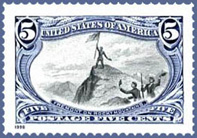
The expedition reached its western extreme with Frémont taking a small advance party to explore the Wind River Mountains. He climbed what he believed to be the highest peak in the range, now named Mt. Frémont, and at the summit raised a flag sewn by his wife Jessie. An image of the event was later captured on one of the stamps of the 1898 Trans-Mississippi Exposition series and the 1998 centennial reprint.
Generally, it is assumed that Jessie helped him to write the subsequent report (S.Doc. 243, 27-3), widely regarded as one of the best-written reports of the period. 1,000 extra copies were authorized, and it was so popular that the full text was included two years later in the printing of the report from the 1843-44 expedition. Consequently, this remarkably well-written account of early western exploration has never been out of print since its original publication. It stands as one of the most widely read and readable of all government reports.
To accompany the report, Preuss and Frémont together prepared a wonderful map, credited to Frémont, of the Oregon Trail as far west as South Pass. The first of his important maps of the West, it was soon supplanted by the 1845 and 1846 maps, not to mention the landmark 1848 map.
Look for the second half of Frémont's life in a future issue.


